Back Roads Diary: The Lillooet Loop
The Lougheed Highway and beyond
The mountains around Vancouver limit the possibilities for driving in and out of the city. If you're not headed for the USA there are only two options: north along highway 99 or east through the Fraser Valley. Almost everyone will go east, and of those folks almost all will take highway 1. There are back road alternatives, though...
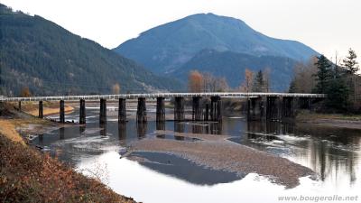
Highway 7, aka the Lougheed Highway, runs on the north side of the Fraser River. At its western end it splits into three routes through Metro Vancouver, all of which are urban and busy. East of Mission it's a two-lane back road along scenic hillsides and cutting a corner through farm country. Along the way are many good photo stops, especially for wildlife-spotting and photography: Dewdney Bridge, Vedder Canal, Harrison.
At the east end of highway 7, turn north onto highway 1. Although it may seem strange to refer to the Trans-Canada Highwayas a "back road", that's what this section has been, ever since the Coquihalla Highway opened as an alternative. The drive through the rugged Fraser Canyon is dry and hot, and the terrain markedly different from other parts of BC. Sights include the old Alexandria Bridge, Hell's Gate tramway, and near-desert at the north end. The road itself is of significant interest, winding through tunnels and under railroad tracks.
For this drive, we don't travel the whole Canyon. Halfway up, turn onto highway 12 at Lytton. There isn't much to see there these days; the town burned down in 2021 and, as of 2024, they still haven't rebuilt. The highway continues the winding drive along the Fraser, to Lillooet. It's a bigger town, and a good place to stop for lunch.
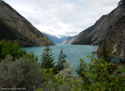
Moving on from Lillooet, take highway 99 south towards Vancouver. Stop at Seeton Lake then head over the pass. In winter this road is more dramatic, and Cayoosh Point particularly worth a stop. On top of the pass are some good places for hiking or skiing, depending what time of year. Finally descend past Duffey and Joffre Lakes to Pemberton.
From Pemberton it's a short drive to Whistler, and from there on the Sea to Sky Highway back to Vancouver. Although scenic, this last stretch is nobody's idea of a back road. If you're out to avoid cities, consider turning around and going back through Lillooet - perhaps to Cache Creek and Merritt, if you're driving this as the start of a bigger tour.
Just the facts
You can reach Mission by a number of different routes from Vancouver. Taking highway 1 to Abbotsford then highway 11 to Mission will probably be fastest. I generally prefer the Mary Hill Bypass, highway 7B. If you are really devoted to back roads, it is possible to follow small country roads along the south side of the Fraser, from highway 17 skirting Langley to the intersection with highway 11 (and from there to Mission).
Between Pemberton and Vancouver, on the other hand, there is only one drive: the Sea To Sky highway. There are many good sights along it, but it is undeniably busy and the traffic can raise blood pressures.
Hope River General Store, on highway 1, has an excellent bakery. I have yet to figure out the ideal time to stop by for fresh cinnamon rolls, but around 10 am is a good bet. DeRoche General Store is also worth a stop for its beef jerky and other meat snacks. If saving money is a concern, wait until at least Mission to fill up on gas; there is a sharp drop in price once you exit the TransLink Zone around Vancouver.